Update on Mt Wickham
LDC is conducting a large-scale gully remediation project on Mt Wickham.
Since initial works were completed in November 2018, 745mm of rain has fallen on site. This is equal to the annual average and well above the January average of 125mm.
Here is an update on the site following the rain in January and early February.
Photos and summary of site condition are courtesy of Damon Telfer, Fruition Environmental Consultancy. Damon collected water samples from Mt Wickham for the LDC project by helicopter on Wednesday, 6 February.
The Landscape Remediation Activity Area aims to develop effective and economical solutions for gully remediation that can be rolled out across the BBB catchment – and across other reef catchments.
Mt Wickham is the first demonstration site that has been established to showcase different methods of treating large-scale features, according to erosion and soil type.
Other sites will be established in the BBB this year and the LDC team will investigate a framework to record and compare cost-effectiveness of the various trial treatments.
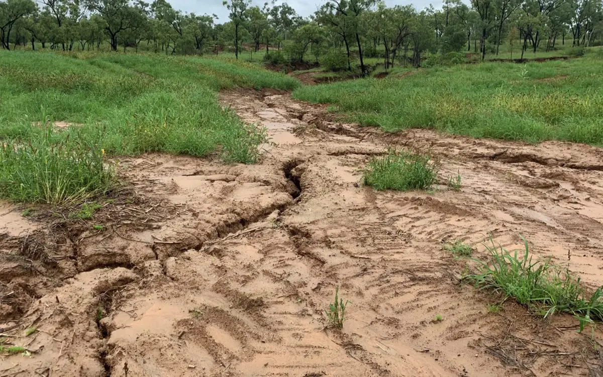
The recent rain event – more than 640mm in January – certainly tested the Mt Wickham site. On the whole it has held up well. Minor repair works is needed and these will be carried out within the next month.
By LDC Project Manager Andrew Yates
Snapshot of total rainfall on Mt Wickham since remediation
- >640 mm of rainfall fell in January, (Jan average 125mm). The most significant event was 312mm on the 9th and 10th January, followed up with 250mm in the next two weeks.
- At its peak water was flowing 1.8m over the treatment site (measured through WQ monitoring)
Backwatering buried the water quality monitoring sensors with silt on the control site.
Burdekin and Bowen rivers are in flood
- All community water quality sample sites in the BBB were in flow and samples have been collected.
- All NESP sites triggered. Collection of samples could not occur in first 48 hours due to adverse weather (therefore nutrient analysis not possible). All samples have now been collected for sediment analysis.
- TropWater flew over part of the BBB catchment, Burdekin and flood plume to capture imagery in February.
Treatments have held up
However, maintenance priorities have been identified.
- A drainage line has formed in the main basin. With soils, completely saturated water has found its preferred path. Treatment options to prevent further erosion are now being discussed.
- An existing erosion site at the head of the system (identified after the first rain event) is likely to have eroded further. This will be treated with a rock chute in March (weather permitting).
- Trials for treatment of tunnelling will be put in place if more form.
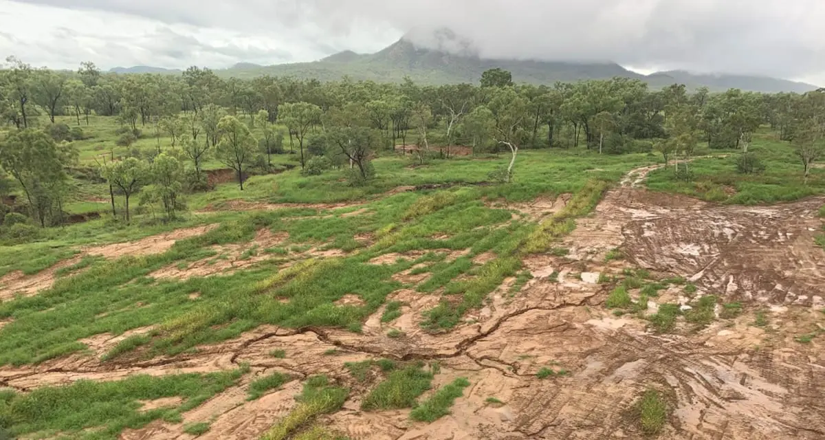
Basin 1a from the air
- There is a large area of bare ground were maintenance occurred following the early January rainfall event. Re-seeding did not occur, as seed was not available at the time. Re-seeding is a high priority.
- The new drainage line can be seen and requires treatment.
Mt Wickham treatment site – 6 February 2019
Why Mt Wickham was chosen as a demonstration site
The LDC project contracted gully remediation experts to develop a range of criteria to help locate a ‘typical’ large-scale sodic gully rehabilitation study site in the BBB.
Criteria included biophysical traits such as:
- size of the gully;
- soil type; and
- possessing typical erosion features the LDC project is trying to fix.
Other factors include (but not limited to) that the site can:
- demonstrate a range of gully remediation techniques and solutions;
- show the outcome of various remediation treatments, and if they are transferable and cost effective;
- be easily accessible;
- be able to host field days; and
- a willing landholder to host a demonstration site. (We are grateful to the owners of Mt Wickham for allowing the project to undertake remediation works on their property).
On ground monitoring and integration with National Environmental Science Program (NESP) 2.1.4. research shows that the total suspended sediment (TSS) concentrations vary considerably between gully sites in the BBB, with the highest mean concentrations being measured at the Mt Wickham site (coming in at ~ 57,000 mg/l). This gully has highly sodic sub-surface soils.
By comparison, other gullies being monitored reached peak concentrations about 10% of those at Mt Wickham (between ~5000 and ~11,000 mg/l).
The total nitrogen (TN) concentrations follow a similar pattern to TSS when comparing the control and treatment sites.
Interestingly, although Mt Wickham has much higher TSS concentrations than the other sites, the TN values are not statistically different.
The demonstration site will be monitored and evaluated using a range of practice, vegetation, runoff and water quality measures.
CSIRO has installed monitoring stations at two gullies at Mt Wickham – the treatment gully that will undergo remediation and a control gully for reference.
Each system is comprised of the following components:
- metal stand or frame;
- ISCO water quality sampler;
- depth transducer;
- turbidity sensor;
- telemetry communications;
- rain gauge; and
- camera.
The purpose of a trial
The Landscape Remediation Activity Area is about trialling various remediation approaches in an effort to determine cost-effective solutions that can be transferred to other projects and catchments.
More than 12 months’ worth of rain fell in January resulting in the need for some temporary measures to protect constructed structures, to allow time for landscape repair to take effect.
Provision exists within the budgets for ongoing maintenance of sediment control structures.
Work will continue at Mt Wickham in March, weather permitting, including minor repair and continuing scheduled work.
We continue to record the effect of the work through CSIRO on-ground water quality monitoring equipment to develop a cost-benefit analysis.
The effectiveness of the structures trialled will be communicated to stakeholders throughout the life of the project.
We plan to hold a Field Day at Mt Wickham shortly to show off the results so far.


