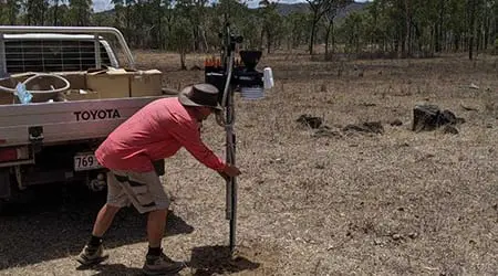
Monitoring baselines established at MLA demonstration sites
LDC has partnered up with Meat & Livestock Australia (MLA) to develop two Producer Demonstrations Sites (PDS) to improve business productivity and profitability.
- The Collinsville Region Regenerative Grazier Network is made up of four properties.
- The Integrated Catchment-wide Priority Weed Management Group is made up of six properties.
Monitoring baselines have been established for all 10 project sites, and automated weather stations have been installed by Neil Paterson from Observant (pictured, right) at each of the Regenerative Grazing Network sites.
Click here to read more about the two PDS.

The Observant Weather Station… data and images from one device.
Monitoring being conducted on the two PDS include:
- Land Condition assessments for treatment versus no treatment sites, using the PATCHKEY land condition assessment methodology, and permanent photo points;
- Before and after drone footage for the priority weed management group (to show effectiveness of weed treatment);
- Installation of automated weather stations for the regenerative grazing network sites (to localise weather at the paddock scale so landholders can make informed decisions that depend on the weather and climate);
- Forage budgeting and other estimates of pasture production (the VegMachine remote sensing tool) will be undertaken after each wet season.
Producers will also be recording comparative production and measuring animal performance between treatment versus no treatment sites.
PATCHKEY used to monitor land condition at each PDS
By Grazing Support Officer Sheridan Callcott
Patchkey monitoring will be carried out each year across the life of the two Producer Demonstration Sites.
Developed by CSIRO, Patchkey is one monitoring tool used by NQ Dry Tropics, and the LDC project, to measure land condition in the Burdekin catchment.
Patchkey provides information about land condition at the ‘patch’ scale (>1m diameter), and the distribution, condition and size of these patches can be used as a quantitative indicator of land condition trends and their relationship to grazing patterns.

Grazing Support Officer Sheridan Callcott
This data can help landholders develop grazing management strategies which can improve hydrological function and reduce run-off and soil loss from grazed landscapes.
The data is also used to validate practice change at the paddock scale.
Patchkey is a slightly more detailed framework of the ABCD land assessment.
It categorises a grazed ‘patch’ into the ABCD condition guide then it further identifies as to where it sits within that condition score.
The conditions are scored from:
- A1, A2 Condition.
- B1 to B6 Condition.
- C1 to C11 Condition.
- D1 to D11 Condition.
Having that next level of breakdown of the ABCD framework allows for smaller changes to be identified in the ‘patch’.
A patchkey site usually consists of three, 100m transect lines spaced approximately 30m apart. Depending on what is to be captured in the recording, it can be done at either a paddock scale to give an approximate representation of the paddock or on a smaller scale for a specific intervention area such as a gully project.
For a project, two sites are established, one near where treatment has been applied or a new paddock or new trough has been put in and one on the control site where it has similar characteristics but no intervention, to measure the impact of the treatment on the land condition.
The area taken into consideration along the 100m transect line is approximately 1m squared and the method used is contiguous patch recording, so every significant change along the transect line is recorded.
It factors in:
- the main type of growth form such as 3P (grasses that are palatable, perennial and productive), Annual or Bare if its the majority;
- basal size of the grass or plant percentage;
- ground cover percentage;
- percentage of litter on the ground (leaves and rotting timber); and
- erosion level (insignificant, low, medium, high).


