Soil sampling conducted across the BBB
The Department of Resources has collected soil samples across the BBB to help assess and understand the variability of soils in the region.
The Department of Resources has collected soil samples across the BBB to help assess and understand the variability of soils in the region. The data will also improve mapping products and extension activities.
Soil scientists from the Department of Resources are collecting soil data in Great Barrier Reef catchments where data is limited or outdated.
The collection and interpretation of soil and land resource information is required to asses the variability of soils and landscapes, and to demonstrate how this variation affects land use, for example agricultural suitability land management and land degradation risks.
This field work was part of the 2020-21 ‘Soil and land conservation technical support for priority hotspots in Reef catchments’ project.
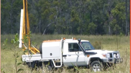
In April, the Department of Resources team spent time in the BBB, in particular the Broken River and Little Bowen River catchments. They worked closely with LDC field officers to shortlist sampling locations and liaise with landholders to coordinate the visits.
Site data will help support soil characterisation and understanding in the BBB as well as improve input data and information into mapping products and extension activities.
Soils are being described for: texture, colour, mottles, structure, segregations, coarse fragments, field pH, permeability and drainage.
Site analysis includes: location, slope, landform element, landform pattern, surface condition, erosion, geology, lithology and vegetation.
Representative soil core depths: 0-10cm, 10-20cm, 20-30cm, 50-60cm, 80-90cm, 110-120cm, 40-150cm.
The results will be stored on the Queensland Government’s Soil and Land Resource information (SALI) database, made available to the public through the Queensland Globe website and the Queensland Spatial Catalogue.